
Beureukaih:Santorin (GR), Exomytis, Vlychada Beach -- 2017 -- 2999 (bw).jpg
Seunipat hasé peusaneut: 800 × 533 piksel Resolusi la'én: 320 × 213 piksel | 640 × 427 piksel | 1.024 × 683 piksel | 1.280 × 853 piksel | 2.560 × 1.707 piksel | 5.472 × 3.648 piksel.
Beureukaih aseuli (5.472 × 3.648 piksel, rayek beureukaih: 6,28 MB, MIME jeunèh: image/jpeg)
Ehtisa
| Hareutoë |
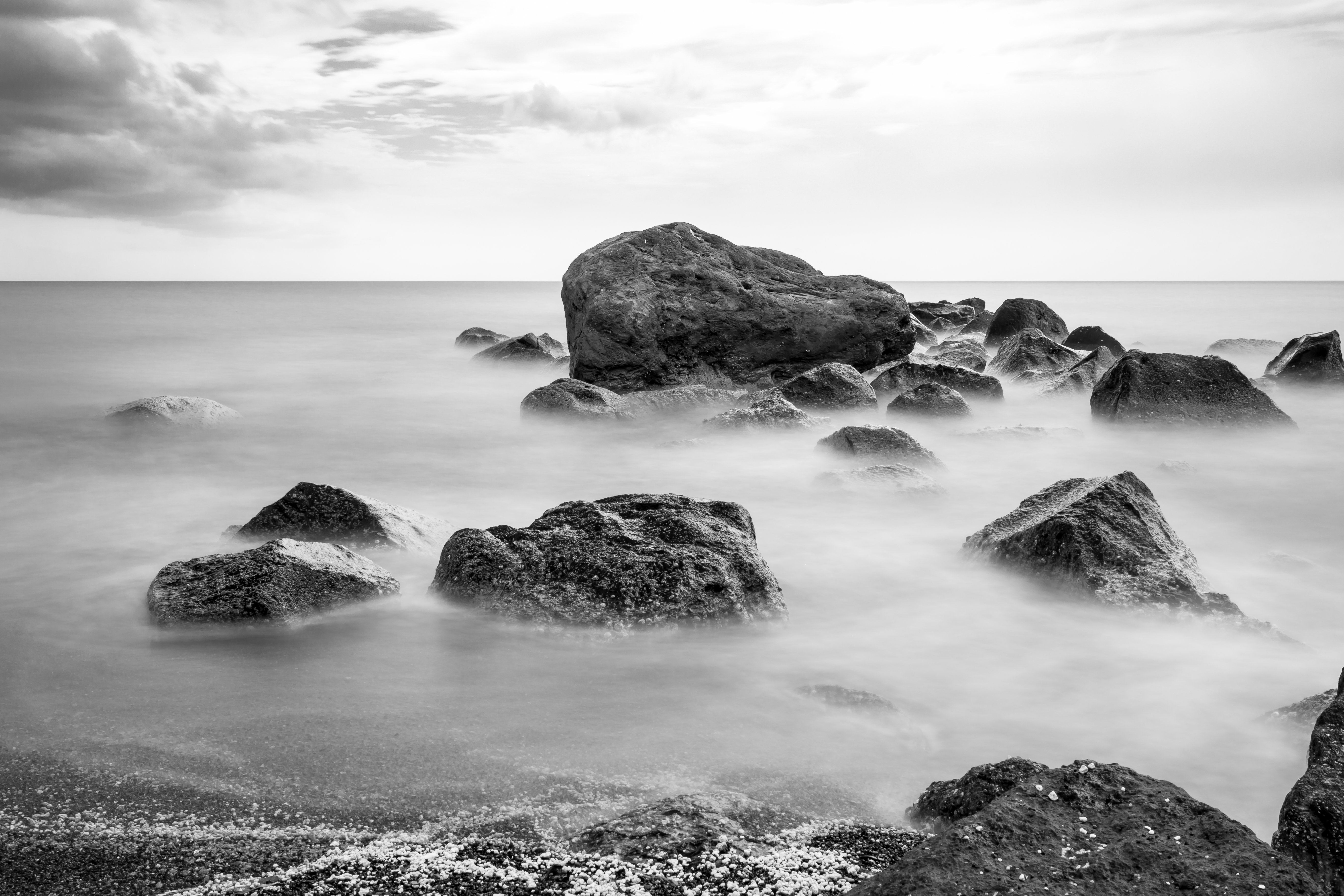
Deutsch: Vlychada Beach in Exomitis, Santorin, Griechenland
English: Vlychada Beach in Exomitis, Santorin, Greece
Ελληνικά: Παραλία Βλυχάδα στον Εξωμίτη, Σαντορίνη, Ελλάδα
Français : Plage de Vlychada à Exomitis, Santorin, Grèce
Português: Rochas na praia de Vlychada em Exomytis, Santorini, Grécia
Українська: Пляж Вличада в Екзомітіс, Санторіні, Греція |
||||||||||||||||||||||||||||||
| Location | |||||||||||||||||||||||||||||||
| Menggambarkan | pantai – Daerah pesisir laut di mana pasir diendapkan dari laut oleh arus air pasang | ||||||||||||||||||||||||||||||
| Technical Specifications |
|
||||||||||||||||||||||||||||||
| Image data |
|
||||||||||||||||||||||||||||||
| Uroë buleuën | Diambil pada 29 Buleuen Sikureueng 2017, 13:33 | ||||||||||||||||||||||||||||||
| Asai | Buet droe | ||||||||||||||||||||||||||||||
| Ureuëng peugöt |
|
||||||||||||||||||||||||||||||
| Idin (Ngui lom beureukaih nyoe) |
 .svg) I. Licence
This photograph is protected by copyright law. However, it may be used for free by anyone, provided it is used in accordance with the license Creative Commons License “Attribution-ShareAlike 4.0 International” (CC BY-SA 4.0). These include, among other things, the naming of the author and the license, as well as the setting of a link to the license text or its complete imprint. The attribution should be done as follows:
Please read the text of the license carefully before using the photograph. If you do not agree with the conditions of the license or if you do not understand these conditions, please refrain from using the photo. If you have any questions regarding the license or the reuse of the image, please contact me before using it. If you do not comply with the terms of the license, you do not acquire any right to use the image. If you need another license to use, please contact the author before using.
For informations about the licence see section Jeunèh lisensi or as human-readable summary or as full licence text at Creative Commons. In addition to the above, a link to the source - so this page with the descriptions and license terms - is appreciated. More information or examples of use can be found at re-use (with example file). The Attribution Generator is helpful in licensing matters.
As an alternative to the Creative Commons License CC BY-SA 4.0, the Free Art License (from version 1.3) may also be used.
II. Fairness
From printed materials and other tangible products that use that work, the user is asked to send a copy to the author as thank you. However, this is not a condition for the use of the photo, but a voluntary service. The mailing address can be requested via the contact options.
Please note that the author had quite considerable effort to draw up this file. Thus, it is only fair to comply with the conditions of free licenses listed here. In the case of violation of the license conditions, the rights granted hereunder will expire automatically.
III. Disclaimer
Please note that the license applies solely for the reuse of the photograph itself. The license doesn't grant you any right regarding the depicted object (eg, copyright or proprietary rights) or the personality rights of the person eventually shown. (See licences and non-copyright restrictions.) I do not grant any warranty that the subsequent use of the photograph is legally possible concerning the object or person shown in the photograph. You are responsible to check and respect these rights in the publication in the respective medium or country.
The author is not responsible for the accuracy of the information contained herein (description, title, etc.). Likewise, the author assumes no liability for further use. Please note the general disclaimer and please read reusing content outside Wikimedia too.
IV. Contact
|
||||||||||||||||||||||||||||||
| Versi lainnya |
|
||||||||||||||||||||||||||||||
| Atribusi (required by the license) | Dietmar Rabich / Wikimedia Commons / /
|
||||||||||||||||||||||||||||||
| URL Singkat | https://w.wiki/9Aw6, https://w.wiki/_ts6w (Shortlink) |
||||||||||||||||||||||||||||||
| Keywords | Βλυχάδας, Δήμος Θήρας, Δημοτική Κοινότητα Εμπορείου, Ελληνική Δημοκρατία, Εξωμύτης, Θήρα, Σαντορίνη, Beach, Bewegung, Bewegungsunschärfe, Bild des Tages, Black, Black and white, Black-and-white, Black-and-white photography, Bodies of water, Dimos Thiras, dorp, Dünen und Strand, Egeo, Ellinikí Dimokratía, Emborio, Exomitis, Exomytis, Exzellentes Bild, Featured picture, Fotokunst, Geographie, Geologie, Gewässer, Graustufen, Grecia, Grecja, Greece, Griechenland, Herbst, Küste, Landscape, Landscape photography, Landschaft, Landschaftsfotografie, Langzeit, Langzeitaufnahme, Langzeitbelichtung, Long exposure, Meer, Meere und Ozeane, Natur, Nature photography, Naturfotografie, Naturschutzfotografie, Ocean, Ostrov, Ozean, Picture of the day, Qualitätsbild, Quality image, Řecko, Santorin, Santorini, Santoryn, Schwarz, Schwarzweiß, Schwarz-weiß, Sea, Strand, strand (kust), Thira, Umweltfotografie, Vlichada, Vlychada, Wasser, Weiß, Welle, Wetter, White, Wolke, 2017 | ||||||||||||||||||||||||||||||

,_Exomytis,_Vlychada_Beach_--_2017_--_2999.jpg)
,_Exomytis,_Vlychada_Beach_--_2017_--_2999_(bw)_-_2.jpg)

| Lokasi kamera | | Lihat gambar ini dan gambar di sekitarnya di: OpenStreetMap |
|---|
Penilaian
|
This image was selected as picture of the day on Wikimedia Commons for 7 November 2018. It was captioned as follows: Other languages:
Português: Rochas na praia de Vlychada em Exomytis, Santorini, Grécia. |
Jeunèh lisensi
Dietmar Rabich, pemilik hak cipta dari karya ini, dengan ini menerbitkan berkas ini di bawah ketentuan berikut:
Berkas ini dilisensikan di bawah lisensi Creative Commons Atribusi-Berbagi Serupa 4.0 Internasional.
Atribusi: Dietmar Rabich
- Droeneuh geubri idin keu:
- ngui sajan – seumalén, seumipreuek ngön pumeuét buet
- peugöt ulang – ngui keulayi gamba
- Meunurôt syarat di yup nyoe:
- atribusi – Droeneuh peureulèe neutuléh asai karya nyoe lagèe nyang geupeuteuntèe lé ureueng tuléh atawa ureueng po hak (tapi kön ngön meukeusud keuneuk promosi karya ureueng nyan).
- weuëk saban – Apabila Anda menggubah, mengubah, atau membuat turunan dari materi ini, Anda harus menyebarluaskan kontribusi Anda di bawah lisensi yang sama seperti lisensi pada materi asli.
Catatan
Foto
|
You like this photograph? That pleases me very much! You would like to see more of my pictures? With pleasure.
Wikimedia Commons has a large number of my photographs available under a free license. This makes it easy for you and me. The license details are for each picture. The use is easier than you think, because in essence, this is just the attribution in the form I want. In addition, usage notes are listed for each picture. And if it does not fit, just ask. My contact information is also available with every photograph. |
,_Fira_--_2017_--_2598.jpg)

.jpg)
,_Exomytis,_Vlychada_Beach_--_2017_--_2999_(bw).jpg)
,_Exomytis,_Vlychada_Beach_--_2017_--_2999_(bw).jpg)
,_Exomytis,_Vlychada_Beach_--_2017_--_2999_(bw).jpg¶ms=036.337763_N_0025.433117_E_globe:Earth_type:camera_region:GR-L_&language=ace)
,_Exomytis,_Vlychada_Beach_--_2017_--_2999_(bw).jpg)
Riwayat beureukaih
Neuteugon bak uroe buleuen/watèe keu neu-eu beureukaih nyoe ‘oh watèe nyan.
| Uroe buleuen/Watèe | Beuntuk ubeut | Dimènsi | Ureueng ngui | Beunalaih | |
|---|---|---|---|---|---|
| jinoë hat | 22 Buleuen Siplôh 2017 15.19 | | 5.472 × 3.648 (6,28 MB) | XRay | new development |
| 22 Buleuen Siplôh 2017 14.04 |  | 5.472 × 3.648 (9,21 MB) | XRay | fixes | |
| 7 Buleuen Siplôh 2017 12.57 |  | 5.472 × 3.648 (10,1 MB) | XRay | VicuñaUploader 1.23 |
Seuneungui beureukaih
Hana laman nyang na meupawôt u beureukaih nyoe.
Neungui beureukaih global
Wiki laén di yup nyoe geungui beureukaih nyoe:
- Seuneungui bak az.wikipedia.org
- Seuneungui bak be-tarask.wikipedia.org
- Seuneungui bak crh.wikipedia.org
- Seuneungui bak cv.wikipedia.org
- Seuneungui bak de.wikipedia.org
- Seuneungui bak en.wikipedia.org
- Seuneungui bak es.wikipedia.org
- Seuneungui bak fr.wikipedia.org
- Seuneungui bak hu.wikipedia.org
- Seuneungui bak hy.wikipedia.org
- Seuneungui bak it.wiktionary.org
- Seuneungui bak ka.wikipedia.org
- Seuneungui bak ko.wikipedia.org
- Seuneungui bak lbe.wikipedia.org
- Seuneungui bak lez.wikipedia.org
- Seuneungui bak mk.wikipedia.org
- Seuneungui bak my.wikipedia.org
- Seuneungui bak nl.wikipedia.org
- Seuneungui bak os.wikipedia.org
- Seuneungui bak pt.wikipedia.org
- Seuneungui bak ru.wikipedia.org
- Seuneungui bak ru.wikinews.org
- Seuneungui bak sah.wikipedia.org
- Seuneungui bak tt.wikipedia.org
- Seuneungui bak uk.wikipedia.org
- Seuneungui bak vep.wikipedia.org
- Seuneungui bak zh.wikipedia.org
,_Exomytis,_Vlychada_Beach_--_2017_--_2999_(bw).jpg)