
Beureukaih:City of London skyline from London City Hall - Oct 2008.jpg

Seunipat hasé peusaneut: 800 × 420 piksel Resolusi la'én: 320 × 168 piksel | 640 × 336 piksel | 1.024 × 537 piksel | 1.280 × 671 piksel | 2.560 × 1.343 piksel | 8.441 × 4.427 piksel.
Beureukaih aseuli (8.441 × 4.427 piksel, rayek beureukaih: 10,81 MB, MIME jeunèh: image/jpeg)
Ehtisa
| Hareutoë |
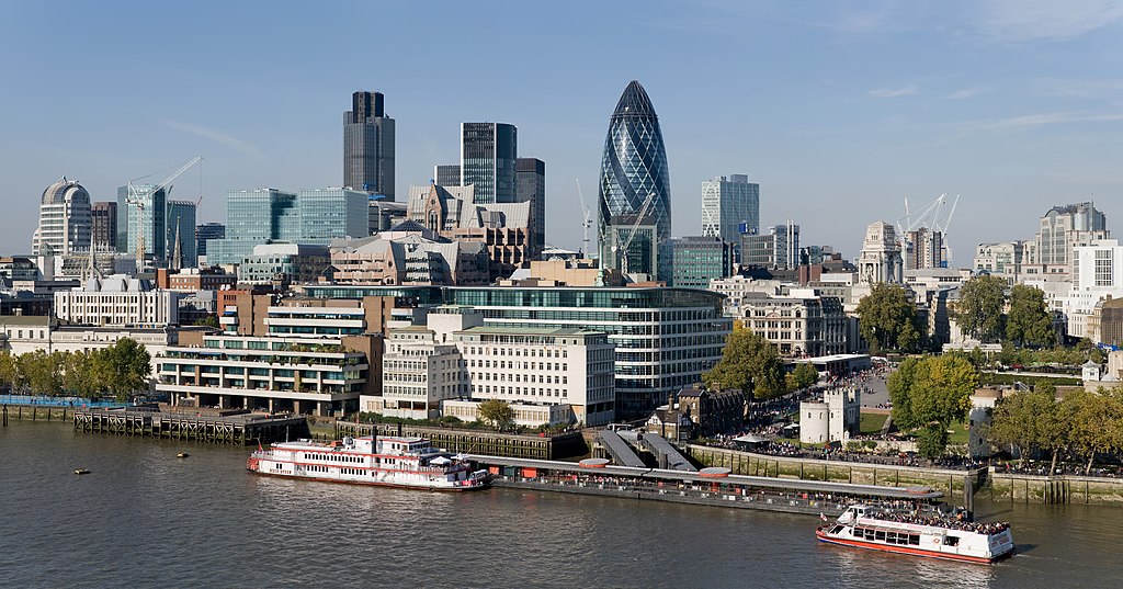
English: The City of London skyline as viewed toward the north-west from the top floor viewing platform of London City Hall on the southern side of the Thames. In the foreground: Dixie Queen and Millennium Time at Tower Millennium Pier. This is a 5 segment panoramic image taken by myself with a Canon 5D and 24-105mm f/4L IS lens. |
| Uroë buleuën | |
| Asai | Buet droe |
| Ureuëng peugöt | Diliff |
| Idin (Ngui lom beureukaih nyoe) |
Summary:In using this image or any subsequent derivatives of it, you are required to release the image under the same license. As such, any reproduction of this image, in any medium, must appear with a copy of, or full URL of the license.Attribution of this image to the author (DAVID ILIFF) is also required, preferably in a prominent location near the image.No other conditions may be added to, or removed from this license without the permission of the author and copyright holder.Suggested attribution: "Photo by DAVID ILIFF. License: CC BY-SA 3.0"Please review the full license requirements carefully before using this image. If you would like to clarify the terms of the license or negotiate less restrictive commercial licensing outside of the bounds of GFDL/CC-BY-SA, please contact me by email, or if you don't have a Wikipedia account you can either leave a message on my talk page with your contact details and your request, or you can contact me on Facebook. Please also send a 'friend request' to ensure that I am aware of your message. |
| Versi lainnya |
  |
| Lokasi kamera | | Lihat gambar ini dan gambar di sekitarnya di: OpenStreetMap |
|---|
Jeunèh lisensi
Saya, pemilik hak cipta dari karya ini, dengan ini menerbitkan berkas ini di bawah ketentuan berikut:
beureukaih nyoe geulisènsi ngön lisènsi Creative Commons Attribution-Share Alike 3.0 Unported.
- Droeneuh geubri idin keu:
- ngui sajan – seumalén, seumipreuek ngön pumeuét buet
- peugöt ulang – ngui keulayi gamba
- Meunurôt syarat di yup nyoe:
- atribusi – Droeneuh peureulèe neutuléh asai karya nyoe lagèe nyang geupeuteuntèe lé ureueng tuléh atawa ureueng po hak (tapi kön ngön meukeusud keuneuk promosi karya ureueng nyan).
- weuëk saban – Apabila Anda menggubah, mengubah, atau membuat turunan dari materi ini, Anda harus menyebarluaskan kontribusi Anda di bawah lisensi yang sama seperti lisensi pada materi asli.

|
Geubri idin keu seumalén, seumipreuek ngön/atawa meuubah dokumen nyoe ngön syarat GNU Free Documentation License, Versi 1.2 atawa nyang leubèh barô geupeuteubiet lé Free Software Foundation; ngön hana Bagian Invarian, hana Tèks Ôn-Keue, ngön hana Tèks Ôn-Likôt. Saboh seunalén nibak lisènsi nyoe geupeutamong lam bagian ngön nan GNU Free Documentation License. |
Droëneuh jeuët neupiléh lisènsi peuniléh Droëneuh.
Penilaian
|
|
| Annotations | This image is annotated: View the annotations at Commons |
Riwayat beureukaih
Neuteugon bak uroe buleuen/watèe keu neu-eu beureukaih nyoe ‘oh watèe nyan.
| Uroe buleuen/Watèe | Beuntuk ubeut | Dimènsi | Ureueng ngui | Beunalaih | |
|---|---|---|---|---|---|
| jinoë hat | 24 Buleuen Nam 2012 14.41 | | 8.441 × 4.427 (10,81 MB) | Tim! | Reverted to version as of 12:54, 12 October 2008 |
| 12 Buleuen Siplôh 2008 19.54 |  | 8.441 × 4.427 (10,81 MB) | Diliff | {{Information |Description={{en|1=The City of London skyline as viewed toward the north-west from the top floor viewing platform of London City Hall on the southern side of the Thames. This is a 5 segment panoramic image taken by myself with a Canon 5D an |
Seuneungui beureukaih
Hana laman nyang na meupawôt u beureukaih nyoe.
Neungui beureukaih global
Wiki laén di yup nyoe geungui beureukaih nyoe:
- Seuneungui bak af.wikipedia.org
- Seuneungui bak ar.wikipedia.org
- Seuneungui bak az.wikipedia.org
- Seuneungui bak az.wiktionary.org
- Seuneungui bak be-tarask.wikipedia.org
- Seuneungui bak be.wikipedia.org
- Seuneungui bak bg.wikipedia.org
- Seuneungui bak bs.wikipedia.org
- Seuneungui bak ca.wikipedia.org
- Seuneungui bak cy.wikipedia.org
- Seuneungui bak de.wikipedia.org
- Seuneungui bak en.wikipedia.org
- Tower Millennium Pier
- Wikipedia:WikiProject UK geography
- Wikipedia talk:WikiProject UK geography
- User:Diliff
- Portal:London/Pictures/Wikipedia featured pictures
- Wikipedia:Featured pictures/Places/Panorama
- Portal:United Kingdom/Featured picture
- Wikipedia:WikiProject UK geography/Announcements
- Wikipedia:Featured pictures thumbs/13
- Metropolis
- Wikipedia:Featured picture candidates/October-2008
- Wikipedia:Featured picture candidates/City of London skyline
- Wikipedia:Wikipedia Signpost/2008-11-08/Features and admins
- Wikipedia:Wikipedia Signpost/2008-11-08/SPV
- Wikipedia:Picture of the day/June 2009
- Template:POTD/2009-06-08
- User talk:Diliff/Archive6
- List of central business districts
- Wake Up to Money
- User:Quibik/Montage
- Portal:London/Featured picture
- Portal:London/Featured picture/12
- User talk:Sabrebd/Autoarchive 4
- Talk:United Kingdom/Archive 27
- User talk:Ottoniel B
- Portal:United Kingdom/Featured picture/47
- Talk:London/Archive 11
- Template:User Part Time Resident-London
- User:DexDor/Categorization
Eu leubèh le neungui ban dum nibak beureukaih nyoe.