
Beureukaih:Demis-kurils-russian names.png
Hana resolusi nyang leubèh manyang.
Demis-kurils-russian_names.png (663 × 462 piksel, rayek beureukaih: 70 KB, MIME jeunèh: image/png)
Ehtisa
| Hareutoë |
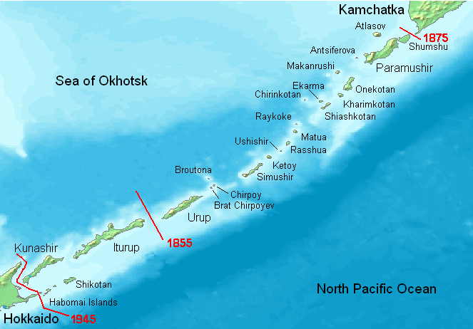
English: Kuril Islands overview map with current Russian names (English transliteration). Borders of Shimoda Treaty (1855) and Treaty of St. Petersburg (1875) shown in red. Currently all islands northeast of Hokkaido are administered by Russia. Note: Ushishir actually consists of 2 islands: Ryponkicha (northeast) and Yankicha (southwest).
Bahasa Indonesia: Peta yang menampilkan nama-nama pulau di Kepulauan Kuril dalam bahasa Rusia (transliterasi Inggris). Perbatasan dalam Traktat Shimoda (1855) dan Traktat Sankt-Peterburg (1875) ditunjukkan dalam warna merah. Sekarang semua pulau-pulau di timur laut Hokkaido dikuasai oleh Rusia. Catatan: Ushishir sebenarnya terdiri dari 2 pulau: Ryponkicha (timur laut) dan Yankicha (barat daya). |
| Uroë buleuën | |
| Asai | Buet droe |
| Ureuëng peugöt | Hardscarf |
| Versi lainnya |
|

Jeunèh lisensi
This image is in the public domain because it came from the site https://www.demis.nl/products/web-map-server/examples/ and was released by the copyright holder. Permission is granted to copy, distribute and/or modify this map since it is based on free of copyright images from: www.demis.nl. See also approval email on de.wp and its clarification.
|
| This work has been released into the public domain by its copyright holder, www.demis.nl. This applies worldwide. Di sejumlah negara, tindakan ini tidak memungkinkan secara sah; bila seperti itu: www.demis.nl memberikan siapa pun hak untuk menggunakan karya ini untuk tujuan apa pun, tanpa persyaratan apa pun, kecuali yang ditetapkan oleh hukum.
|
Riwayat beureukaih
Neuteugon bak uroe buleuen/watèe keu neu-eu beureukaih nyoe ‘oh watèe nyan.
| Uroe buleuen/Watèe | Beuntuk ubeut | Dimènsi | Ureueng ngui | Beunalaih | |
|---|---|---|---|---|---|
| jinoë hat | 23 Buleuen Limöng 2008 01.27 | | 663 × 462 (70 KB) | ChrisDHDR | added the border since 1945 |
| 24 Buleuen Siblaih 2006 03.00 |  | 663 × 462 (70 KB) | Hardscarf | Kuril Islands overviewmap with actual Russian names (English transliteration). Borders of Shimoda Treaty (1855) and Treaty of St. Petersburg (1875) shown in red. Currently all islands northwest of Hokkaido are administered by Russia. Note: Ushishir actua |
Seuneungui beureukaih
laman di yup nyoe mupawôt u beureukaih nyoe:
Neungui beureukaih global
Wiki laén di yup nyoe geungui beureukaih nyoe:
- Seuneungui bak af.wikipedia.org
- Seuneungui bak ar.wikipedia.org
- Seuneungui bak az.wikipedia.org
- Seuneungui bak be.wikipedia.org
- Seuneungui bak bg.wikipedia.org
- Seuneungui bak br.wikipedia.org
- Seuneungui bak ca.wikipedia.org
- Seuneungui bak ckb.wikipedia.org
- Seuneungui bak cs.wikipedia.org
- Seuneungui bak da.wikipedia.org
- Seuneungui bak de.wikipedia.org
- Kurilen
- Vierte Kurilenstraße
- Kurilenstraße
- Zweite Kurilenstraße
- Nemuro-Straße
- Fries-Straße
- Luschin-Straße
- Krusenstern-Straße
- Jekaterina-Straße
- Boussole-Straße
- Kurilenstraßen
- Nadeschda-Straße
- 27. Armee (Japanisches Kaiserreich)
- 91. Division (Japanisches Kaiserreich)
- 5. Regionalarmee
- Benutzer:Bluemel1/Juli 1990
- Vorlage:Navigationsleiste Kurilenstraßen
- Seuneungui bak en.wikipedia.org
- Seuneungui bak en.wiktionary.org
- Seuneungui bak es.wikipedia.org
Eu leubèh le neungui ban dum nibak beureukaih nyoe.