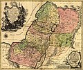
Beureukaih:1759 map Holy Land and 12 Tribes.jpg

Konten halaman tidak didukung dalam bahasa lain.
Nibak Wikipedia

Beureukaih aseuli(2.000 × 1.676 piksel, rayek beureukaih: 1,74 MB, MIME jeunèh: image/jpeg)

Beureukah nyoe asaijih nibak Wikimedia Commons ngon kadang geungui lé proyèk-proyèk laén. Keutrangan bak on keutranganjih geupeuleumah di yup nyoe.

Ehtisa

Tobias Conrad Lotter: Latina: Terra Sancta sive Palæstina exhibens no ſolum Regna vetera Iuda et Israel in ſuas XII Tribus diſtincta, ſed etiam eorundem diverſarum ætatum conditionem et facta in Sacris Paginis indicata.   (Wikidata search (Cirrus search) Wikidata query (SPARQL)  Create new Wikidata item based on this file)
Seniman/Pembuat
Tobias Conrad Lotter  (1717–1777)  wikidata:Q106511
 
Nama alternatif
Lotter, Tobias Conrad / Lotter, Tobias Konrad
Deskripsi copper engraver, cartographer ngön publisher
Tanggal kelahiran/kematian 1717 Sunting ini di Wikidata 1777 Sunting ini di Wikidata
Tempat kelahiran/kematian Augsburg Augsburg
Tempat pengerjaan
Pengawasan otoritas
artist QS:P170,Q106511
Judul
Latina: Terra Sancta sive Palæstina exhibens no ſolum Regna vetera Iuda et Israel in ſuas XII Tribus diſtincta, ſed etiam eorundem diverſarum ætatum conditionem et facta in Sacris Paginis indicata.
Hareutoë
English: English Translation: The Holy Land or Palestine showing not only the Old Kingdoms of Judea and Israel but also the 12 Tribes Distinctly, Confirming their Locations Diversely in their Ancient Condition and Doing So as the Holy Scriptures Indicate.
Uroë buleuën 1759
date QS:P571,+1759-00-00T00:00:00Z/9
Bahan hand-colored
Ukuran Tinggi: 47 cm; lebar: 57 cm
dimensions QS:P2048,47U174728
dimensions QS:P2049,57U174728
Library of Congress Geography and Map Division Washington, D.C. 20540-4650
Catatan Scale [ca. 1:695,000]
Sumber/Fotografer Geography and Map Division, Library of Congress
Versi lainnya

Jeunèh lisensi

Ini adalah suatu perbanyakan fotografis dari sebuah karya seni dua dimensi. Karya seni tersebut berada pada domain publik karena alasan berikut:
Public domain

This work is in the public domain in its country of origin and other countries and areas where the copyright term is the author's life plus 100 years or fewer.


You must also include a United States public domain tag to indicate why this work is in the public domain in the United States.
Posisi resmi Wikimedia Foundation adalah bahwa "faithful reproductions of two-dimensional public domain works of art are public domain, and that claims to the contrary represent an assault on the very concept of a public domain". Untuk detilnya, lihat Commons:When to use the PD-Art tag.
Oleh karena itu, perbanyakan fotografis ini juga dianggap berada pada domain publik. Mohon diperhatikan bahwa hukum lokal mungkin saja melarang atau membatasi penggunaan kembali berkas ini di wilayah hukum anda. Lihat Commons:Reuse of PD-Art photographs.

Captions

Add a one-line explanation of what this file represents

Items portrayed in this file

menggambarkan Indonesia

tipe media Indonesia

image/jpeg

checksum Inggris

9aec441e2a748bb1f14eca6e42dd7d08ce2e766b

metode penentuan Indonesia: SHA-1 Indonesia

ukuran data Indonesia

1.827.878 Bita

tinggi Indonesia

1.676 piksel

lebar Indonesia

2.000 piksel

Riwayat beureukaih

Neuteugon bak uroe buleuen/watèe keu neu-eu beureukaih nyoe ‘oh watèe nyan.

Uroe buleuen/WatèeBeuntuk ubeutDimènsiUreueng nguiBeunalaih
jinoë hat12 Buleuen Sikureueng 2005 17.43Beuntuk ubeut keu seunalén tiëp 12 Buleuen Sikureueng 2005 17.432.000 × 1.676 (1,74 MB)Humus sapiens~commonswiki1759 map: Terra Sancta sive Palæstina exhibens no folum Regna vetera Iuda et Israel in fuas XII Tribus diftincta... Source: Library of Congress historical maps Category:Historical maps of the Middle East Category:Israel

laman di yup nyoe mupawôt u beureukaih nyoe:

Neungui beureukaih global

Wiki laén di yup nyoe geungui beureukaih nyoe:

Eu leubèh le neungui ban dum nibak beureukaih nyoe.